|
||||||
|
|
||||||
|
||||||
|
|
||||||
|
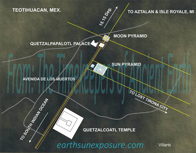
TEOTIHUACAN
|
Neither
the Teotihuacan Citadel nor its pyramids align geographically with the
cardinal points. The promenade "Avenida de Los Muertos" The Avenue
of the Dead, does not align with a celestial body or a cardinal point; it has
a bearing of about 15.15degrees. Also, it has an unexpected layout; the
larger pyramid of the Sun is set to the side of the main promenade, while the
smaller one, the pyramid of the Moon heads up the arrangement. Some have ventured as far as comparing the
layout with that of a computer circuit board. For our study, the geographical
alignment of the complex was the focus. Archaeologist Marquina (1951)
believed the pyramid of the Sun, whose axis is perpendicular to the promenade
was arranged so to face the sunset.
During the summer solstice on June 22, 2014 the sun's azimuth at
sunrise was 65.07degrees, thus the sun illuminated the eastern diagonal side
of the pyramid. In winter the sun sets at about 80degrees to the western side
of the pyramid. Earlier,
we had explained that lines drawn on either side of the Pyramid of the Sun,
with a bearing of 106.14degrees, nearly perpendicular to the promenade, lead
to northern Colombia where the two lines encompass the length of the steps at
the Lost City of Tyrona. The alignment of the pyramid with Tyrona makes
Tyrona's location geometrically related or dependent on the promenade and the
pyramid's azimuth. Following the promenade's line southward around the globe
to the south Indian Ocean, passes over northern Antarctica and reaches the
South Indian Ocean plate. |
|||||
|
|
|
|
||||
|
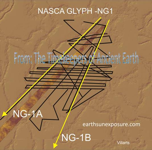
The
Indo Australian plate boundary runs east-west for about three thousand six hundred
miles between Australia and Antarctica. Many of these deep ocean plate
boundary lines have been reported by oceanographers and mapped with Google©. Conducting a close examination of the ocean with Google©, at
an eye altitude of about 250 miles, we were able to see the ridge line.
Intrigued by the South Indian Ocean (SIO) ridge line's very peculiar
geometric pattern, we proceeded to trace it. Our tracings are similar to
those reported but clearer than the computer generated ones. We named this ridge line The Great South
Indian Ocean Glyph (SIO Glyph). In this study, this was the first close
encounter with geology and ridge lines. The layout of some sections of the
glyph were reminiscent of lines we had seen with similar patterns elsewhere,
somewhere on earth at another place: at Nasca. At
Nasca we had found line glyphs depicting the same graphic technique; a single
line tracing, zigzagging, turning squarely side to side and eventually
doubling back onto it returning to the beginning of the drawing. The graphic
shown, is one of several similar glyphs found at Nasca (14.64degreesS. 75.06
degrees W), this one resembles the segment of the SIO Glyph we are referring
to; the plate ridge line is found at 40.96degrees S 78.67degrees E. |
NASCA
GLYPH 1
|
|||||
|
|
|
|||||
|
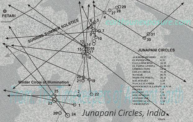
JUNAPANI CIRCLES
|
These circles are located at 21.199
degrees N 79.00 degrees E, and as mentioned earlier the circles are scattered
but they follow a general direction; they follow the winter solstice circle
of illumination, as shown in the graphic. The circle is the line shown going
through circles 4, 16, 17 and 26. Also shown In the graphic is the direction
of the sun at sunrise at the summer solstice (4,27,28,29). The Junapani circles align
reciprocally with: Callanish, the Medicine Wheel,
the Sine circles, the El Infiernito phallic menhirs circle, Göbekli Tepe and Stonehenge; that is they point to each other
with an alignment in the design of the structures within each site. For the
other alignments shown in the graphic, although the direction of the
alignment points to the location of the structure or citadel, a great circle
drawn at the angle of the alignment reaches the location but does not align
with any feature of the structure. Some of these alignments could be thought
of as serendipitous, but, in some instances the alignment is confirmed by the
multiplicity of structures at other archaeological sites that are found on
the same path. This is the case of the alignment of circles (22, 19, 14) headed
north over the North Pole and crossing over North America into México.
Staring near the coast of the Golf of México the alignment finds the Citadel
of El Tajin (20.447 degrees N 97.376 degrees W) crosses over two of its
pyramids in the direction of its main alignment and continues southwest
passing near the Pyramid of Yohualichán (20.062 degrees N 97.503 degrees W), then past
the largest Mesoamerican Citadel of Cantona (19.552 degrees N 97.488 degrees
W) and further south near the pyramid of Teteles (18.627 degrees N 97.717
degrees W). |
|||||
|
|
|
|||||
|
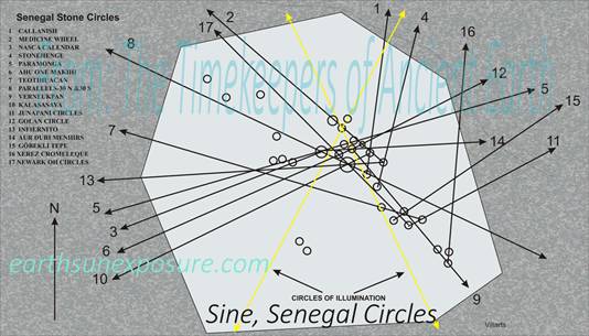
The Senegal stone circles site is
located northwest of the town of Sine (13.695 degrees N 15.535 degrees W). It
is one of two sites about 44 miles from each other. The other site is in the town
of Wassu. Both sites contain numerous circles, the total number is unknown
some of the sites remain still unexplored. They differ in design; the Sine
site -see graphic- shows how the circles are scattered in no particular
design, although the general direction points northwest, the other site (the
main known circles) are geometrically aligned. The Sine site is fairly unique in
design, it consists of many small circles in apparent disarray; the largest
circle is nine meters in diameter.
There are other sites with similar layout; one is in Junapani in
India, shown above, the other is in the Sajama desert. Junapani is similar in
design and coincidentally has the same number of circles -or close to it. As
shown above that design also follows a general direction. Sajama is vastly
larger and its circles are not menhir arrangements but Kiva like structures
easily confused with animal corrals. The circular structures are scattered
over an area of over twenty thousand square kilometers vastly larger in size
over the other two. These structures also appear to be in total disarray;
however they also tend to align in one direction. The Sine Senegal circles
roughly follow the summer solstice circle of illumination |
SINE SENEGAL CIRCLES
|
|||||
|
|
|
|||||
|
Copyright©2014-2015 |
web page
design: villarts@charter.net |
|||||