|
|
|
||
|
|
|||
|
|
|||


|
CONTACT NEW DEVELOPMENTS IMAGE FILE
ORDER NOTE:
The information contained in this website is based on original research and actual
measurements taken with Google© earth which can be easily
reproduced following the methodology described in the book. Alternatively,
you may obtain copies of the original research data by contacting us. Thank
You. ANCIENT ARCHITECTURE AND THE ARCHEOLOGY OF TIME MEASUREMENT Architectural
archaeology, in general, assumes ancient buildings or structures were
constructed to serve an anthropological need such as shelter or religious
purposes, in other instances they might have been constructed to ensure human
sustenance as in the case of grain storage and water conveyance. These
studies therefore look at how the spaces and designs might have served those
needs and in conjunction with archaeological evaluations a clearer picture of
ancient societies emerges. The emerging picture is muddled in many instances
by the inability of these studies to definitively determine how many cultural
layers have been deposited at a site through millennia. Was the intent and
design of a site and its structures used for the intended purpose across the
ages, is a vital question?
One
clear instance of alternate use of a structure is the obelisk. In Egypt
obelisks were, presumably, erected in some instances to worship the god Ra.
In the latter part of the third century BC Eratosthenes used an obelisk and
water well to measure the circumference of the earth. The importance of his
achievement is, not only because it was perhaps the first time an
architectural construction was used as an instrument with a scientific purpose
without having an immediate societal benefit, but, for the 'first time' the
earth sun exposure relationship was used for the task; the angle of
illumination and the shadows cast by the obelisk and the reflection of the
sun in the well were used to calculate a measurement of astronomical
proportions. Were obelisks intended as religious objects to begin with, or
did they have a more secular purpose? We will never know. Unfortunately many
of these obelisks were dismantled and sent to Europe and America. Their
specific locations and heights might have told a different story. The
narrative of Eratosthenes' experiment is well documented and we accept it
immediately as factual. The question is; was it really the first time an
architectural construction was used for scientific purposes; in this case as
a measuring instrument to take earth measurements? Were other earlier
archeological monuments, also, used as measuring instruments or perhaps specifically
designed and built to achieve earth measurements of the same order of magnitude,
but their purpose was not documented and it was forgotten through millennia?
Is their documentation implicit in their physical geometries? We
are well aware of the various archaeological sites with structures which show
alignments with the sun at the solstices; such as Machu Picchu and
Stonehenge. These structures we are ready to accept were constructed for
religious or agricultural purposes, but find it hard to imagine there was a
scientific purpose behind their designs, irrespective if they were inhabited
or not or used for ceremonial purposes. Were those 'ceremonial' purposes the
embers of long forgotten scientific inquiry? The precision of the alignment
these structures have with the sun at specific times of the year invite us to
divine a more fundamental rationale for their planning, construction and use;
the purpose of their existence. Were the angles of their structures, walls
and lines included in their designs related to the angles at which the sun
rays illuminate the earth at specific times of the year? Are the relative
global positions of these structures as important as the locations of the
Eratosthenes' obelisk and water well were for his calculations; these are
found respectively, in Alexandria and Syene (Aswan)
some five hundred miles from each other, perhaps in a grander global scale?
We believe the anthropological needs of our current civilization do not
justify the enterprise and design undertaken to build some of the well known
grander sites. Our civilization may have overlaid its fingerprint over layers
of previous many other layers in many instances cloaking the original purpose
of these structures. Our
approach to answer these questions was to investigate if there were geometric
patterns generated by the structures locations on earth. Several authors had
looked at alignments and geometric positioning of structures with respect to
the earth's poles and geographic topographical markers, but none of their
work suggested the perspective of our inquiry: we consider each archeological
site a global topographic marker whose position and orientation could be
their function. Eventually we found
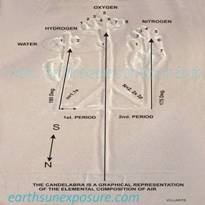
something that might have been created to serve such function; an ancient
glyph with the shape of an instrument in Paracas,
Peru: The Candelabra, a geo glyph with
clearly defined purpose; a pointer, as author Von Daniken had described it because of its appearance, but unfortunately could not
fathom a use for it. The 'pointer' characteristic is inherent in its
geometric design, we determined; its objective is to point to the tip of
South America the Tierra de Fuego region at 175⁰ from its location. An arc line drawn
following the Candelabra's main stem, at that azimuth 'coincidentally' passes
through Monte Verde Creek the site where 14k year old human remains were
found. The intentionality in the design is assured by one of the prongs which
points at 180⁰,
precisely, while the other is parallel to the main one. It is remarkable that
the authors would know about the cardinal points (geometry was not developed
until the sixth century BC) and as we confirmed later are used repeatedly as
reference points. This angle difference in direction with respect to the
cardinal points in the presence of a cardinal point alignment is found at
many monuments around the world. In most instances arc lines traced at one or
both of the angles embedded in the object or structure -cardinal and non
cardinal azimuths- lead to important places. For instance, the direction of
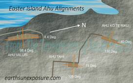
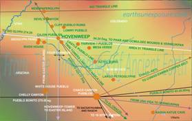
the inland side of Ahu Vinapu points to the Hovenweep Pueblos at 0⁰ due north
while the sea side at 1.2⁰ points to the Penasco Pueblo in the Chaco Canyon. In
the study we evaluated well over one hundred archaeological sites. For each,
the solar illumination angles at the solstices were established as well as
the architectural features which reflect those angles, i.e. a record of the
angle the sun shone at the time of their construction. We also determined the
relationships that exist between sites. Those relationships were confirmed by
plotting the sites' geographic coordinates in a 3D Cartesian coordinate grid.
In many instances, the results show these sites' location coordinates are
points on great circles around the earth. The pyramid of Cheops sits at the
intersection point of two such circles. This is discussed in detail below. "ANCIENT MONUMENTS OR FEATURES IN THEIR DESIGNS
ALIGN WITH THE SUN AT SPECIFIC TIMES OF THE YEAR. FOR SOME, THE SUN'S
SOLSTICE ALIGNMENTS ARE NOTE WORTHY; THESE LOCAL EVENTS ARE NOT
GEOGRAPHICALLY ISOLATED, TOGETHER THEY TIME THE EARTH'S ASTRONOMICAL
MOVEMENTS" The
Timekeepers is a book about this research which explains the rationale behind
the engineering or architectural design and the geographical location of
ancient archaeological structures or sites; from the simple but elegant lines
at Nazca to the Egyptian Pyramids. The discoveries briefly presented here are
explained in detail in the book. In it direction is given in plain language
for anyone familiar or newly introduced to the subject to follow; readers
with minimum training, with a computer and Google© earth can easily retrace
and reproduce the data presented. Alternatively Google© .kml files of the research results may be obtained from the web site. In
this newly expanded edition of the book, previously published entitled; Nasca & Easter Island- An ancient Global Plan
Revealed (2014), significant advances in the original research are presented.
The continuation of this research reveals how the architects of ancient
monuments built into their designs the Earth Sun Exposure astronomical
relationship. In this edition a scheme
of broad implications based on geographic and cartographic data is assembled
which shows many of the monuments of antiquity were designed and placed to
serve as Timekeepers. As such each monument in the scheme marks a place on
earth where the sun shines at a specific time and angle during a year's
cycle. The
new data shows that the archaeological legacy is the product of a
civilization or civilizations who accurately measured the earth's planetary
motions. They measured the earth's axis tilt and left a record of this
knowledge. The value of the obliquity angle of the earth's axis was recorded
in lines, structures and glyphs at many locations the world over, most of
them remote from each other, but are connected through their geometries.
These ancient civilizations may have lived on earth, perhaps centuries
earlier than is currently believed; this conclusion is derived from the
monuments' current sun exposure alignments vs. the alignment they were given
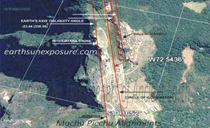
at the time they were built. The key site, the foundation for this analysis
is Machu Picchu where we find a sun exposure historical record built in its
layout, buildings, terraces and the Intihuatana Stone.
This research
reveals the architectural and geographic planning of monuments and other
ancient megalithic structures was guided by precise astronomical
measurements; the magnitude of this work was driven, perhaps, by the desire
to leave a permanent record! "...The most comprehensive
cartographic study of archaeological sites to date..." "...Fully documented.
Geographic coordinates for most locations cited are provided..." "...Two hundred and eighty
fully illustrated pages, with graphics and data tables..." PREVIEW
full articles under NEW DEVELOPMENTS which provide insight into the foundation of this innovative approach to the evaluation
of archaeological sites. Click on the graphics on the first column below, to read a short note on each site
covered in the book. Archaeology of Time Measurement Google© data files are
available in .kmz format!, request list HERE
|
||||||
CALCULATE
THE SUN'S POSITION IN THE SKY FOR ANY PLACE, DATE AND TIME OF DAY USING THE
CALCULATOR BELOW | ||||||
|
Enter the desired location in the SEARCH box on the upper left.
You may enter the place's name (New York, Paris..) or the coordinates if
known, either in decimal or degrees. Below, just above the map on the left enter the desired
date and time. The calculator will display the time zone automatically. When the parameters are set click on the
blue button 'EXECUTE' The result will show the sun's path and the specified
hour highlighted. Click on the arrow to see the elevation angle at dawn, noon
and dusk. The default display is the 'Sun Path' other choices are available
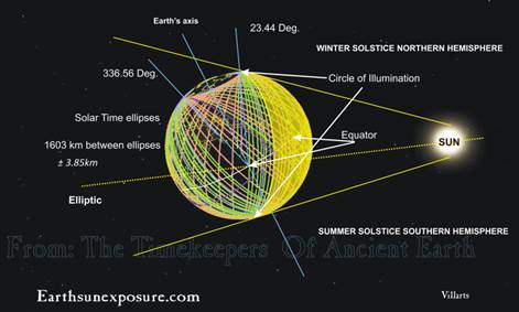
in the drop down list. THE ARCHAEOLOGY OF TIME MESUREMENT REVEALS HOW SOME
ANCIENT STRUCTURES WERE DESIGNED TO
INCLUDE IN THEIR DESIGNS A LINE PERPENDICULAR TO THE ANGLE OF INCIDENCE OF THE
SUN AT THE SOLSTICES, I.E. THE CIRCLE OF ILLUMINATION. THE GROUP OF THESE
STRUCTURES FROM AROUND THE WORLD MARK EQUAL TIME SPANS WHICH MEASURE THE
AVERAGE LENGTH OF THE DAILY CYCLE; THEY FORM A CHRONOMETER. |

|
|
|
|
|
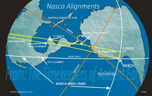
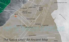
NASCA LINES'
ALIGNMENTS |
||
|
|
|
|
|
THE NAZCA LINES
ARE A MAP |
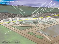
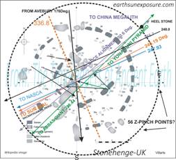
SACSAYHUAMAN
'SUN DIAL' |
TAHAI COMPLEX-
EASTER ISLAND, CHILE |
|
|
|
|
|
HOVENWEEP & CHACO CANYON PUEBLOS |
||
|
|
|
|
|
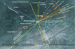
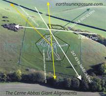
ABBAS GIANT, UK |
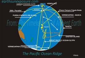
PACIFIC OCEN
RIDGE |
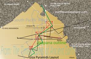
THE GIZA PYRAMIDS ALIGNMENT |
|
|
|
|
|
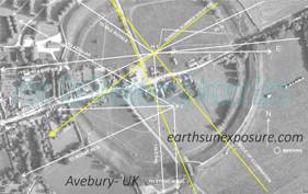
AVEBURY, UK |
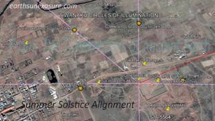
SUMMER SOLSTICE AT KALSASAYA TIHUANAKU BOLIVIA |
|
Solve a Geometric Problem |
|
AVAILABLE AT AMAZON BUY IT HERE CONTACT US:
villartsone@gmail.com |
|
Copyright©2014-2015 The Archaeology of
time measurement Earth Sun Exposure Web
page design: villarts@charter.net |