|
||||||
|
|
||||||
|
|
||||||
|
|
||||||
|
|
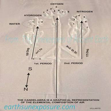
The
Candelabra Paracas Peru The Candelabra's geometry and positioning were
defined with respect to its geographical location (13.794°S, 76.308°W). As in the previous study we began
searching for alignments it could have with other locations. Approaching the Nazca plateau from the NW, the Candelabra, appears as a
welcoming sign; it is carved on the shore in Paracas Perú looking like a 'guide post' pointing to something. The geoglyph is
isolated measuring about 170 meters (595 feet) long it is carved on the north
western face of a low hill at the tip of the peninsula, facing the ocean like
a billboard - in contrast to the other geo glyphs at Nasca,
which are located some one hundred miles away and lie almost flat and can be
easily missed (discovered in 1927).
It does not depict an animal or any other known object. Its shape appears to be a sophisticated
pointer; not a Candelabra, as Von Däniken had
described it in "Chariot of the Gods". Von Däniken suggested it looked like a 'pointer', but never found out what it is pointed
at. We measured its bearing and found the Candelabra's main prong points
south at ~175° to the tip end of South America; Tierra del Fuego. The
prong on the east points 180° We found the candelabra not only, points
to Nasca, but its lines encode directions to
important places and its lobes may encode the chemical composition of air. |
|||||
|
|
|
|||||
|
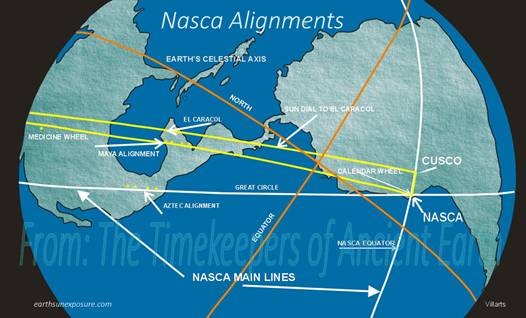
The Nazca Lines Alignments The most prominent
lines on the Nazca plain, visible from outer space
were selected to initiate the study. Their azimuths were measured and
ellipses (The earth is not spherical therefore circles drawn around it are
slightly elliptical) were traced around the globe in those directions. One of
the lines runs at about 324.86°NW and the other line 68.67°NE.
These two angle values are similar to the earth's axis tilt and the angle of
the ecliptic at the summer solstice in the southern hemisphere. Then, the
earth’s celestial axis is tilted -23.44°(336.56°) off the
perpendicular to the orbital plane -the ecliptic. At the summer solstice in the northern
hemisphere, the sun rays fall perpendicular to the sun line at 336.56°
and the axis tilts 23.44° towards the sun. The axis tilt varies, plus or minus
1.3° from its average value of 23.3°. The two white lines shown -see graphic - cross at the
center of the Nazca plateau dividing it into
quadrants, the gray lines are the earth's celestial axis and Equator. The
main line going north aligns with archaeological sites in Mesoamerica; shown
in the map as the Aztec Alignment. |
|
|||||
|
|
||||||
|
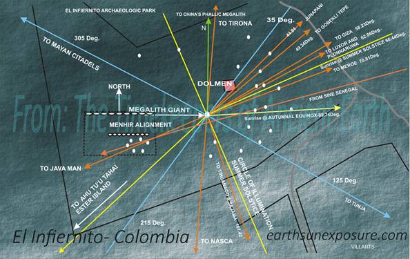
GIANT PHALLIC MEGALITHS OF COLÓMBIA
|
The
El Infiernito is a megalithic site in northern
Colómbia. It has twenty four standing phallic megaliths and several fallen ones;
twenty three are arranged around the middle one and largest. They are
arranged in a radial configuration at specific angles starting from the
northwest at 291° ending on the southeast at 175.59°.
Included are one at 336.0°close to the value of the obliquity
angle of the earth's axis and one at 89.68°close to the celestial Equator's
angle. A line in the arrangement in a 305°NW
direction across the Caribbean Sea, in Nicaragua finds the petro glyphs of Sulutara, in Honduras the Naranjos Mounds and Cerro Palenque. In Guatemala finds the Temple and Citadels ruins
of Quiriguá, Cancuén and Aguateca. The line continues onto México, and in the
state of Campeche in the Yucatán peninsula it finds the Pyramids and Citadels
of; Bonampak, Yaxchilán, Palenque, Villahermosa, Comalcalco and La Venta, then,
across the Gulf of México it encounters the El Tajín Citadel, and the Defensa Pyramid. In all, the
Monolith Giant and dolmen establish a Great Arc that connects sixteen
archaeological sites in its NW-SE direction and on its perpendicular NE-SW
line another Great Arc connects twelve sites. An alignment of the megalith
giant with a peripheral megalith at 167.42° sets the direction of a
great circle which reaches the Ponce megalith in the Kalasasaya Temple in Tihuanaco and continuing south it finds
the Chulpas of Curahuara and cuts through the Sajama desert where it aligns with Nodes 31, 30, 107, 38
and eighteen kiva-like structures. On its northwest
direction the great circle aligns past the Newark Ohio circle and in Canada
crosses by the Churchill Inukshuk. Another alignment from the central megalith
to one on the northeast at an angle of 44.84° reaches the circles at Junapani, India; there a great circle in that direction
aligns with circles alignment 13. Other alignments are with Tyrona, Göbekli Tepe, Giza, Luxor, Polonnaruwa and the pyramid of Meroé. |
|||||
|
|
||||||
|
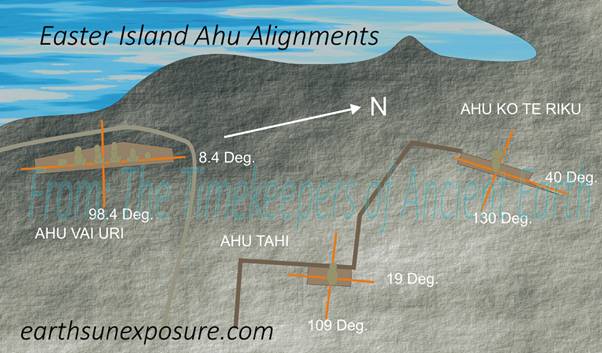
There are three Ahus at this location: Ahu Vai Uri, Ahu Tahai and the famous Ahu Ko Te Riku moai;
the one with eyes. This is the moai who probably inspired the famous question:
"What are you looking at" To find their alignments, lines were drawn
lengthwise across the Ahus and their bearings
measured. It was found, all Ahus are aligned in a
different geographical directionS. Therefore, the Moais atop each Ahu look in
different directions. Lines were drawn
following the Ahus direction and a second line was
drawn, for each, following the line of sight for the individual Moai; that is, perpendicular to their line-up or the Ahu itself, front and back. Some Ahu platforms are trapezoidal and stacked in a pyramidal manner, resulting in the
layers having different azimuths. Ahu Ko Te Riku is a prime example;
the small azimuth differences between the layers point to specific sites
around the globe. Some Ahus have lost their Moais and some are in a poor state of disrepair and the
lines can be drawn only in their general direction. Also, there are various
levels of disrepair. Ahu Uru Ururanga on the east coast (27.15° S 109.34° W) connects Easter Island
with Göbekli Tepe in
Turkey (27.32°N 38.92°E). The Ahu has a
bearing of 61.31°. |
Easter
Island Ahu Alignments
|
|||||
|
|
EASTER ISLAND AHU KO TE RIKU, VAI URI, TAHAI |
|||||
|
Copyright©2014-2015 |
web page
design: villarts@charter.net |
|||||