|
||||||
|
|
||||||
|
|
||||||
|
|
||||||
|
THE NAZCA LINES AND GLYPHS
|
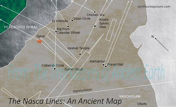
The Nazca Lines Lead to Archeological Sites Following the azimuth of the Nazca Lines as great circles it was discovered that not only temples in Tahiland have corresponding lines at Nazca,
but virtually every site of archaeological interest we tested has a line, as
well. The graphic shows how the lines look like on the Nasca plain, for a few
of the temples. Further study showed that not only pyramids,
dolmens, temples, circles, cairns and any other kind of site of archaeological
interest has a corresponding line in the Nasca plain; so did all
anthropological sites we had included in the first test. In the graphic one
can see Taung Child and Sterkfountaine's line at the bottom. Other sites from North America are also recorded
with their own lines: Hovenweep, UT and the Medicine wheel at Big Horn, WY.
Also, archaeological sites in India; Alamgirpur and Valishali are shown. The
pyramids of Cheops and Chephren, and the Sphinx appear towards the top
center. Also shown are Chichén Itza, the Golan Circle and El Infiernito. |
|||||
|
|
|
|||||
|
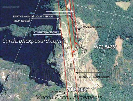
Machu Picchu Was Built on a
Ridge that Follows The Earth's axis Tilt Angle Machu
Picchu is located 1.5 miles high in the Andes, northwest of Sacsayhuaman at about 302 degrees. The citadel sits
on a mountain ridge that runs northwest at 337.83 ⁰,
coincidentally the ridge's direction almost equals the obliquity angle of the
earth's axis. The Intihuatana Stone 'The Sun's hitching Post' is a structure
atop the citadel that aligns with the sun at the summer solstice -another Sun
Dial. The stone lines up at 336.56⁰ with another structure atop the
ridge. Also, the buildings' walls across the plaza and its terraces were
built at the same angle. The Circle of Illumination's angle which at this latitude has a value
of 335.89⁰ is found in some of these stepped terraces. This
reinforces the idea, the ancient architects were aware of how the sun illuminates the earth and the
shift in angle through the equinoxes. The
foregoing indicates that the site for Machu Picchu was likely selected,
because the mountain ridge follows the approximate angle of obliquity of the
earth's axis. The city architects planed the structures to correct the
azimuth to more closely follow the declination of the earth's axis and also
included the exact Circle of Illumination's azimuth in the stepped terrace's design. The Sun Hitching Post
stone's location (-13.162 ⁰-72.545⁰) aligns with the sun at its zenith
when it reaches the solstice culminations, during the spring and autumnal
equinoxes; which start in the southern hemisphere on September 23rd and
March21st. NEW RESEARCH,
provides more detailed insight as we study the INTIHUATANA Stone itself. |
MACHU
PICCHU'S SOLAR ALIGNMENT
|
|||||
|
|
|
|||||
|
THE CHACO CANYON PUEBLOS
|
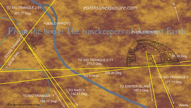
The Chaco
Canyon Pueblos Were Built Exactly North of Easter Island Pueblo Bonito is a quarter mile east of Pueblo del Arroyo, it has
a horse shoe configuration that faces south. It encloses rectangular
buildings and twenty five circular Kiva structures. The largest of these
circular structures, sits at the front-center and is about 52 feet in
diameter and about ten feet deep. This structure is flanked on the east and
west by stone walls that run at different angles. The Western wall line runs
at an angle of 180.0 degrees, whereas the eastern wall line runs at an angle
of 171.17 degrees. The front
of the horseshoe shaped pueblo- see illustration- is enclosed by two walls;
these are not co-linear. The western wall runs east west at 90 and 270
degrees. The purpose of this alignment appears to set the cardinal
coordinates, with the 180 degrees western wall from which all other
alignments depend. The eastern wall confirms this; it runs east at 85.26
degrees. Running this line west at 265.26 degrees, it reaches the island of
O'ahu, passing through Honolulu near Temple Heiau. Continuing on to
Australia, it finds the Cascades petro glyphs, and on the west passes by the
mines of Laverton and Gwalia, and 167 miles north of the Kalgoorlie
mine. The 90 degrees east bound line
cuts through the Pharr Mounds in Mississippi and Rock Eagle in Georgia… |
|||||
|
|
||||||
|
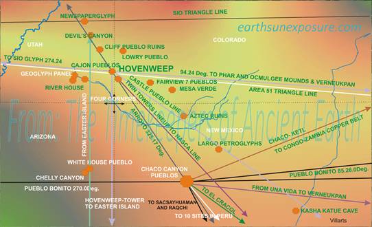
The Hovenweep and Chaco Pueblos align with each other and the
Temple of Viracocha This
Pueblo site has been extensively studied, in particular for its astronomical
solar calendar window arrangements. The windows allow sun rays to illuminate
different wall sections at different times of the year. One of these
illuminated walls displays a spiral.
The Pueblos are found in the canyons around the 'Four Corners' where
the States of Utah, Colorado Arizona and New Mexico meet. These pueblos are
geometrically connected with several archaeological sites around the world.
Some of these connections have already been explained, specifically, those of
the Chaco canyon Pueblos. Following we focus on the Hovenweep structures and
their alignments. We start by showing the geography of the region on the map;
the Four Corners region. Hovenweep is just north of the four corners, which
are marked on the map with dotted lines. The Chaco Arroyo 325.17⁰NW
line passes two miles east of the Hovenweep Twin Towers and the Castle. The
Twin Towers (37.37⁰-109.07⁰) are aligned at an angle of 140.2⁰
following this direction south to Nazca, the line
finds the Nazca line for the towers at 14.68⁰S 75.10 ⁰W |
THE HOVENWEEP PUEBLOS
|
|||||
|
|
||||||
|
Copyright©2014-2015 |
web page
design: villarts@charter.net |
|||||