|
||||||
|
|
||||||
|
|
||||||
|
|
||||||
|
|
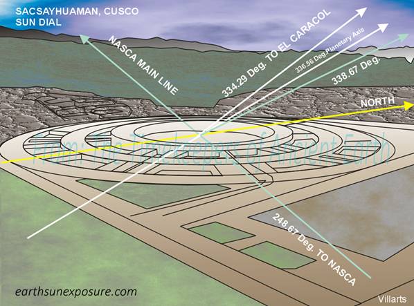
The Sacsayhuaman Fort in Cusco Perú is the
Home of The Sun Dial In Sacsayhuaman, known as the Inca 'Navel of the
World', atop the citadel there is a circular structure in stone similar to
the Nasca Calendar Wheel and the Medicine Wheel in Wyoming, US, known locally
as "The Cusco Sun Dial", i.e. an observatory. See graphic. The Sun Dial has double row stone radii. One of the radius runs NW at an angle close
to the Circle of Illumination and the other perpendicular to it i.e.
parallel to the ecliptic Equator line. One of the dial's radii (335.18°)follows the solar Circle of Illumination line;
which at this latitude has an angle of 335.85°. A NW line (334.21°NW), connects The Cusco Sun Dial in Perú, with the Caracol
observatory in the Yucatán peninsula in México, located 2,600 miles away. The Sun dial is another geodetic marker for the
astronomical Circle of Illumination |
|||||
|
SACSAYHUAMAN
SUN DIAL |
|
|
||||
|
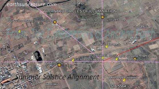
The Temple of Kalasasaya in Tihuanaco -Tiwanaku- Bolivia A common assumption regarding architectural
positioning of monuments is that they were aligned North-South so that the
structure would get the sun from the East at the Solstices. Although all
those structures that are aligned this way do get the sun as prescribed, it
is only in appearance; the actual alignment with the positioning of the sun
at the culmination of the summer solstice is several degrees off 90°. How far off depends on the latitude the
structure is located at and planetary fluctuations. The Tiwanaku and Stonehenge monuments make this
point quite aptly. At Tiwanaku the sun's position at the Summer solstice is
at an angle of 114.53° and at Stonehenge it is at 50.61°; at neither site is the sun due 90° east, as it
may appear to be to the naked eye. This fact is obvious at Tiwanaku. The
Gates of the Sun and the Moon are aligned NS and EW respectively; the two
structures are not on the same 90° line.
However, both Gates are on the 114.53° line, the same as the Ponce Stela, such that at the culmination of the summer solstice these three
structures are aligned with the sun.
At Solar Time 0530 on December 21, 2014 the sun rising on the east
aligned with the head of the Ponce Megalith, and both gates simultaneously at
an angle of 114.54°. |
|
|||||
|
|
KALASASAYA TEMPLE SUMMER SOLSTICE |
|||||
|
|
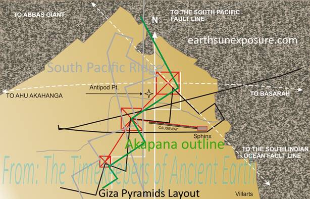
The
Pyramids of Giza Dimensions and Layout are of This World In the graphic, the arc segments for both the Abbas Giant's Mace
and Ahu Akahanga's are shown as they cross over the pyramid of Cheops' apex.
The Abbas Giant ellipse line is about 15degrees off the pyramid's diagonal.
Following is a geometric analysis. We took the SPO Glyph -see below- tracing and
rotated it along its NS axis to obtain a mirror image, followed by a rotation
of of about 75⁰ clockwise about its center middle peak. This transformation yielded
extraordinary results. While maintaining the overall alignment of the SPO
glyph's peaks with the pyramids, some of its lines became aligned with other
features of their layout, this time pointing out their relationship with the
Sphinx and the causeway that connects it with the pyramid of Chephren. Simultaneously, it
aligned the southern line of the glyph's peak, which corresponds to the
pyramid of Cheops, with the diagonal line across the pyramid; which is also
closely followed by the Abbas Giant's Mace circle which, in turn, lines up
with the SIO Glyph. |
|||||
|
THE PYRAMIDS OF GIZA |
|
|||||
|
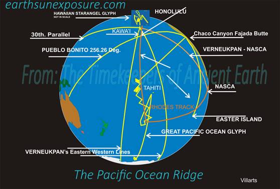
Giza is Aligned to the Ocean
Ridge on The 150° Meridian The
graphic shows that the ridge line is composed of a vertical line which is
located at the 150° longitude meridian, it starts in Antarctica and
ends just south of Tahiti. There it folds back going south-west, then returns
northward in a zigzag manner. The
pyramids’ antipode point is located at the second fold of the ridge line at
about 30.0°S 149.0°W. In the graphic we also show the location of
this point with respect to the ridge line glyph. The ocean ridge line has two
important characteristics: The vertical line runs north-south, and is located
exactly on the 150° longitude meridian. The pyramid of Cheops location
is at about 31°E, so, at its antipode point its longitude is about 149°
and the pyramids' NS alignment runs parallel to the ridge line. This line of
the SPO Glyph is what we believe determined the North alignment of the
pyramids and every other structure thus aligned; such as the Temple of
Kalsasaya in Tihuanaco, instead of their alignments being based on the mobile
Polar Star or the magnetic pole. The SPO Glyph has a natural earth line that
happens to precisely run north south; as such it is a perfect 'immutable'
anchor, which at this point of our research appears to be unique amongst all
ridge lines; if anything it is perhaps the longest and most obvious line. We
believe this line, which runs north all the way from Antartica for 6,000km,
is the Ancient's original geo-centric based source for the "North"
concept. |
|
|||||
|
|
THE PACIFIC OCEAN RIDGE |
|||||
|
Copyright©2014-2015 |
web page
design: villarts@charter.net |
|||||