|
|
|
||||
|
|
|||||
|
|
|||||
|
THE PYRAMIDS OF GIZA: A GEOMETRIC ANALYSIS OF ITS LOCATION &
DESIGN |
|||||
|
The pyramids of Egypt, in particular the ones at Giza, are perhaps
one of the most studied archaeological sites. It can be safely stated that
most methods of human inquiry have been used in their study. All those
studies and analyses, physical instrumental and otherwise, have spawned a
myriad of theories about how and why they were built and by whom and what
their ages might be. None of these
studies, however, have answered to a reasonable certainty the questions: Why are they located where they are
found? Was their locale casually selected; what determined it? Is there a
reason for their alignment bearing north and for their relative sizes,
heights and shapes? Are these monument sites geographically related to others
around the world in any measurable way? Earlier research had shown that many archaeological structures are
aligned with the cardinal points, the pyramids of Giza are the most prominent
but this alignment is found in temples and monuments as far south as the
Temple of Kalasasaya in Tihuanaku,
Bolivia and as far east as the Temple of Angkor Wat
in Cambodia. This is well known. In the book Nasca
& Easter Island, we published the discovery that monuments which do not
align with the cardinal pints, almost invariably, their azimuths set the
direction for a great circle which when followed around the earth coincide or
align with other archaeological sites. Also, sometimes, when two such circles
intersect, one or both points of intersection are marked with a monument as
well. The pyramid of Cheops is one
such intersection point. Giza's Location and Layout
Reflect the Earth's Plate Tectonics In the book N
& EI we reported two alignments for the pyramids
of Giza, specifically, for the pyramid of Cheops. The apex of this pyramid is
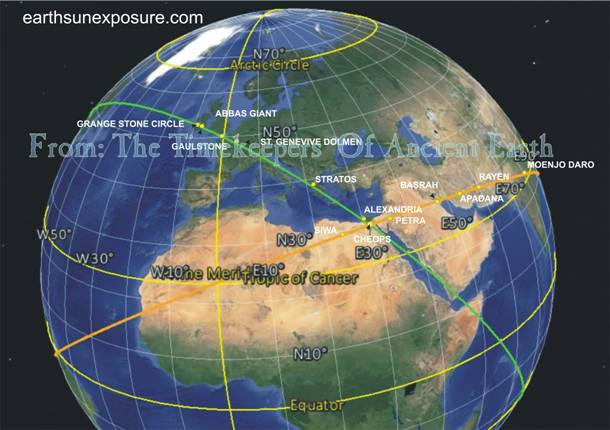
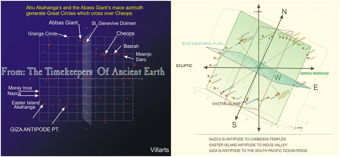
the point where two great circles (ellipses) intersect: A great circle that
can be drawn following the direction of the Abbas
Giant's mace, in southern UK, and another that follows the direction of the Ahu Akahanga, in Easter Island
(EI). This geometry we argued, fixes the
relationship between the locations of these three archaeological sites; which
lead us to conclude, these sites are related to each other in a planned design.
The Ahu Akahanga great
circle -see 3D Graphic below-we reported, could be attributed with having had
the purpose of setting the latitude for the location of the pyramid of
Cheops. In that study we showed that the arc segment of the Akahanga circle which connects the Cheops pyramid with Basrah, reaches the northern most latitude of 30.4⁰N
at a point nearly half the distance between the two locations at longitude 41⁰E.
The Cheops The case for
the Abbas Giant's circle is different. It could
have been drawn anywhere pointing his mace in any direction, except, we found
the direction of his mace traces a great circle which follows almost 3,000km.
of the South Indian Ocean fault line, in the book N&EI we referred to it as the SIO
Glyph. We named it so due to its unique convoluted shape and continued using
the term glyph for the other earth's ocean fault lines that were encountered
and have unique shapes. One such glyph is shown below, which we will discuss
later. The two facts just described
lead us to conclude that the pyramid's location was very likely selected to
be there as prescribed by the fault line and EI's Ahu Akahanga,
and ventured to say that the pyramids' arrangement and north alignment were
probably not just due to stellar alignments, as has been claimed for many
years by a number of researchers3.
The first
question we sought to answer was the reason for the north-south alignment for
the three pyramids. That alignment as well as their claimed alignment with
constellations exhibited, in our estimation, the same problem; the North Star
Polaris is as much a moving target as the constellations are; which we had
argued diminishes the possibility of an ancient civilization having designed
a layout of this magnitude based on alignments with stars -moving targets,
particularly with the presumed limited technology available to them, despite
the myriad theories that exist of how it was done. One such theory quoted in
Building the Great Pyramid7 is Otto Neugebauer's
"On the Orientation of Pyramids" In his theory he proposes a wooden
or stone model called a pyramidion; "The pyramidion is precisely aligned north to south" and
the shadows cast by it by the sun at various times." The method says
nothing about the time element involved over the twenty to thirty years9
it is estimated it took to build them with crews of up to 4,000 men10.
Again, the wooden model relies on Polaris and as mentioned there the method
was only useful in winter.
Creating a geo-centric referencing
system is the subject of study by the International
Terrestrial Reference System, for which various datum have been developed to
create global standards for global positioning, aeronautics, space, defense,
geographic and point of interest POI applications-. "The International Terrestrial Reference System (ITRS) describes procedures
for creating reference frames suitable for use with measurements
on or near the Earth's surface. This is done in much the same way that a
physical standard might be described as a set of procedures for creating a realization of that standard." 6 From the data collected in our earlier study, it became apparent
to us that the tectonic plates positioning were used for this purpose in
ancient times. The current work appears to confirm that belief and strongly suggests
the fault lines could become a useful standard like other geodetic standards
the ITRS uses, such as triangulation pillars or
bronze disc markers placed in various areas of the earth indicating
coordinate points accurate to ten decimal places. In the first
part of the published research, we established a procedure to initiate the
geographic evaluation of the positioning for any structure within a site;
first we determined if the structure is aligned with the Cardinal axis and
which feature(s) of the structure are involved in the alignment. The Giza
pyramids’ alignment with the Cardinal points is common knowledge, well
documented by numerous studies found in the literature7, the
reference given is a fairly comprehensive such references are available review
of pyramid facts, many of which reflect its preferred theories. In the
current study we used the Chephren pyramid to trace
global ellipses following the Cardinal points, each ellipse starting at the
southeast corner of the pyramid, at 90⁰ from each other; thus their
intersection point, half way around the world, determines the pyramid's
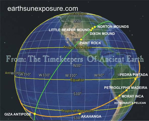
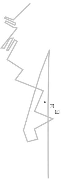
antipode point on earth. In N & EI book chapter: Ocean Lines, we described a fault line
found south of the French Polynesian islands of Moorea
and Tahiti in the South Pacific Ocean (dubbed SPO
Glyph) –a tracing of it is shown left. In the Chapter we discussed how its
shape had been copied and engraved as a glyph at Nazca
by the ancient authors of the Nazca Lines: it is
the perch on which the famous Monkey Glyph stands -see graphic in the Image
File Page-. The graphic shows that the fault line is composed of a vertical
line which is located at the 150° longitude meridian, starting in Antarctica
and ending south of Tahiti. There it folds back going south-west, then returns
northward in a zig-zag manner. The pyramids’ antipode point is located at
the second fold of the fault line at about 30.0°S 149.0°W. In the graphic we
also show the location of this point with respect to the fault line glyph. In
the graphic we enlarged (~650 times) a layout of the pyramids drawn to scale
to depict their relationship. The ocean fault line has two important
characteristics: The vertical line runs north-south, and is located exactly
on the 150° longitude meridian. The pyramid of Cheops location is at about
31°E, so, at its antipode point its longitude is about 149° and the pyramids'
NS alignment runs parallel to it. This line of the SPO
Glyph is what we believe determined the North alignment of the pyramids and
every other structure thus aligned; such as the Temple of Kalsasaya
in Tihuanaco, instead of their alignments being
based on the mobile Polar Star. The SPO Glyph has a
natural earth line that happens to precisely run north south; as such it is a
perfect 'immutable' anchor, which at this point of our research appears to be
unique amongst all fault lines; if anything it is perhaps the longest and
most obvious line. We believe this line, which runs north all the way from
Antarctica for 6,000km, is the Ancient's original geo-centric based source
for the "North" concept. We were able
to safely come to the conclusion that the Pyramids' geometry is related to
this Glyph by surveying the other components of the fault line. The other
features of the fault clearly show the connection the pyramids’ layout has
with the entire fault line's layout, i.e. there is a nearly one to one (1:1)
relationship between all their geometric measurements: geographic alignment
and positioning on the earth, the heights of the pyramids with the glyph's
peaks' heights, and the distance between them. Also, the overall layout's pattern; it is
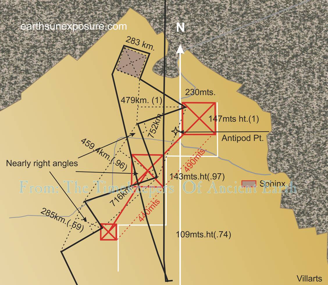
shown as a white 'step' line in the graphic below. Graphic 1
Now the
comparison in numbers: The line that follows the 150° longitude meridian ends
just south of Tahiti, there as mentioned, it folds back SW at an angle of
195° and continues for about 2,000km. From there it returns north-west
following a symmetrical zig zag
path, eventually reaching past the island of Moorea.
The zig zag line has
three major saw tooth-like folds at almost right angles with each other; the peaks that point east, not their
corresponding troughs. The peaks of the three teeth are distanced from each
other as follow: 752km. between the largest in the south and the middle one
to the north and 716km. (.95) between the middle one and the third to the
north of it. The ratio of the distances is shown in parenthesis. The first
two peaks are near equally sized while the third one is the smallest. Their
heights are: 479(1), 459.4(.96), 285(.59) km. The ratio of their heights is
shown in parenthesis. Similar measurements were taken for the Giza pyramids,
the distance between their apices are: Cheops-Chephren-490mts.,
Chephren-Mycerinus-440mts. and their ratio (.90). Likewise the pyramids’
heights (original) and their ratios are: 147(1), 143(.97), 109(.74)mts; comparing the ratios;
heights and distance show near correlation with the fault line’s
geometry. Recall that the pyramids'
geographic location is antipode to the SPO
Glyph. These numerical relationships
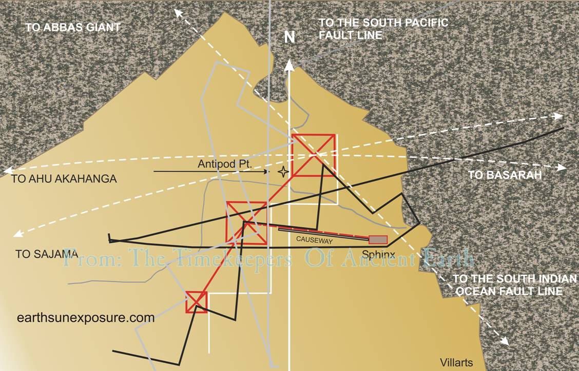
can be better appreciated visually in Graphic 1 shown above. In the graphic, superimposed on a map to
scale of the pyramids, is a tracing of the earth’s SPO
glyph also drawn to scale and then reduced close to the pyramids’ size. The
graphic of the SPO glyph was moved north along its
NS axis, over the North Pole until it reached Giza, then, it was moved about
a degree east to align with the Chephren pyramid.
It is important to emphasize that at this location the SPO
glyph's north becomes its south; as such it makes patent the geometrical
relationship it has with the pyramids' layout; the glyph was geometrically
translated. In this position the (2832
- 2302)/1,000 = 33 In Graphic 2,
the arc segments for both the Abbas Giant's Mace
and Ahu Akahanga's are
shown as they cross over the pyramid of Cheops' apex. The Abbas
Giant ellipse line is about 15⁰ off the pyramid's diagonal. Following
is a second geometric analysis. We took the SPO
Glyph tracing and rotated it along its NS axis to obtain a mirror image,
followed by a rotation of about 75⁰ clockwise about its center. This
transformation yielded extraordinary results. While maintaining the overall
alignment of the SPO glyph's peaks with the
pyramids, some of its lines became aligned with other features of their
layout, this time pointing out their relationship with the Sphinx and the
causeway that connects it with the Chephren
pyramid. Simultaneously it aligned the southern line of the glyph's peak
which corresponds to the pyramid of Cheops, with the diagonal line across it
which is closely followed by the ellipse that lines up with the Abbas Giant's Mace and the SIO
Glyph. This exercise showed the closed
reference matrix that exists between all these elements. The geometric layout
of the Giza complex reflects the exact location and layout of two of earth's
most salient geological features: The South Pacific and South Indian Ocean's
fault lines. Summary; the SPO Gyph set the 150⁰
meridian great ellipse that determined north, the alignments the pyramids
were given, but, not their location along its circumference. The SIO Glyph alignment ellipse would have placed the
pyramids 8km southeast of Alexandria the point of its intersection with the
30⁰(150⁰) meridian. The actual location is approximately one
degree south and one degree east from the ellipsis' intersection. This
location at the antipode point corresponds to approximately the midpoint of
the line that connects the two large peaks on the SPO
glyph; which may have determined the one degree displacement in both
directions. The Abbas Giant and the Ahu Akahanga appear to have
been designed as geodetic markers to help unravel the logic in the design and
layout as was exposed here. Analyzing the pyramids by themselves would have
not revealed the underlying (literally) rationale for their location, layout
and sizes. The triangulation offered by the two geodetic markers provided the
path. In our analysis the SPO Glyph was aligned NS
inverted from its natural alignment in the South Pacific Ocean, also, it was
positioned over the eastern side of the pyramid of Chephren;
the alignment line we used to find the pyramids antipode point- shown in the
graphic as a star near the southwest corner of the pyramid of Cheops. The
geometric translation of the SPO fault lines
tracing -to scale- results in a near perfect superimposition of its layout
over the pyramids' site; this indicates that the variable layout of the
pyramids was fashioned after the immutable fault lines' layout. Graphic 2
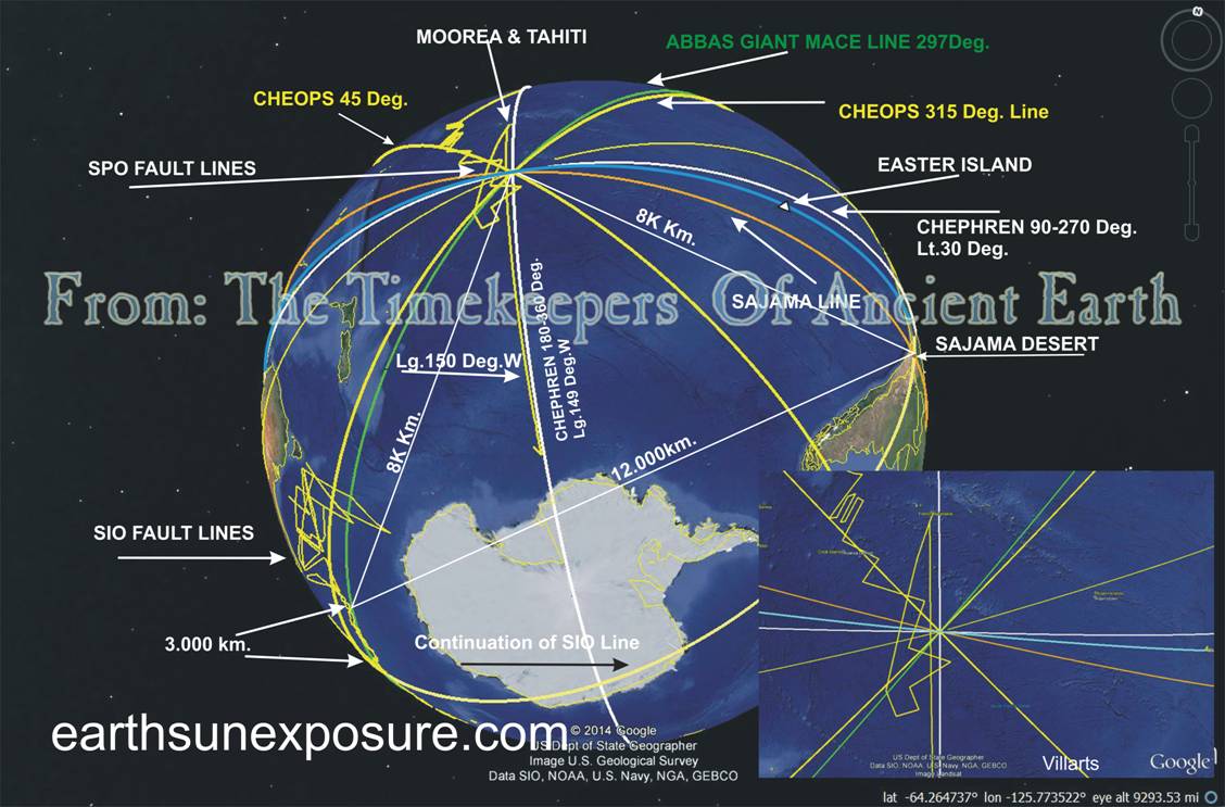
The
relationships described here are only a small part of a greater globe spanning
arrangement. Graphic 4 below is a Google© earth map of the SOP and
SIO fault lines, it shows their locations relative
to Australia, Antarctica, Easter Island and South America, superimposed with
the alignment arc lines-ellipsis- previously mentioned. In addition it shows
another great ellipse (tan) that connects the pyramid of Cheops with the SPO fault line going through the Sajama desert. This
latter connection will be discussed below. In the graphic on the lower left
one can see the 3,000km. segment of the SIO fault line that is closely followed by the Abbas Giant's ellipse. The Ahu Akahanga line appears in blue color and Easter Island is
shown (not to scale) in the upper right quadrant. The SIO glyph has a spur line headed southward at 202.79⁰
starting at -42.434°S 89.837°W and running for 634km. Following this line
over Antarctica it crosses the Sajama desert and the Isla del Sol in Lake
Titicaca; the line is shown at the bottom of Graphic 4. The Sajama desert region has been claimed
to have been the seat of an earlier civilization8, specifically it
is claimed to have been a settlement of the people of Atlantis. The Sajama
region encompasses the pre-Inca civilization region of Lake Titicaca where
the citadels of Tihuanaco and Puma Punku are found. This spur line intersects the tan
ellipse that connects the pyramid of Cheops and the SPO
glyph going through the Sajama desert. The results of our research of the
Sajama Desert show features in the desert determine the position of the
Cheops-Sajama-SPO ellipse. That triangulation makes
the Sajama desert a Point of Interest. It seems that the ancient structures
in the region of Titicaca, Tihuanaco and Puma Punku, were also designed following the same geographical
scheme, as we have discussed, was used for the Giza pyramids, although, to a
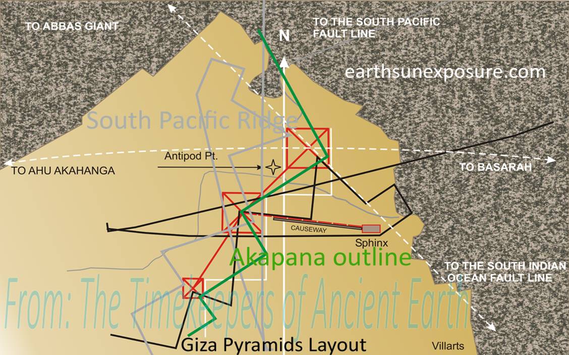
perhaps lower level of geometric sophistication. Graphic 3
In graphic 3
the green line is an outline of the base of the Akapana
Pyramid in Tihuanaco, enlarged to scale, then laid
over the Giza layout. Although the peak ratios for this outline are not as
close as for the SPO Glyph and the Giza pyramids,
it still reflects similar geometry.
These relationships may be emphasized by the fact that the antipode
point for the pyramids is equidistant from Sajama and the point where the Abbas Giant alignment ellipse begins to run parallel to
the SIO fault line, thus forming an 'isosceles
spherical triangle' with the sides ratio of 1:.66:.66, which coincidentally
is approximately the same as Easter Island's shape and has the same side
ratios. The graphic below illustrates
these relationships. Graphic 4
In the book N & EI we observed the near absence of archaeological
alignments the Giza pyramids have with other archaeological structures,
unlike most of the others we presented there do; save for the diagonal
alignments mentioned and a few in the Cardinal directions: immediately north
across the Mediterranean in Turkey we find Aspendos and Altinkaya. To the
east are the Rajajeel and Junapani circles, which appear to be directional
markers. The importance these have were discussed in the book along with
other circles. The geometric alignments discussed here appear to have as their main
purpose to set the location of the pyramids on earth; the alignments found
for the pyramids answer, for this site, the basic questions that set the
objectives for this research: " Why are archaeological structures
located where they are and what determined it?" From the evidence discussed here and other previously reported, we come
to a conclusion: The pyramids had as their
purpose to rise the geological 'markers' inherent in the ocean plate fault
lines to the surface; in full view for a future (our current) civilization,
to learn about the astronomical facts the earth's plates encode. The pyramids
also serve as gigantic sextants that appear to complete the astronomical
connection with the stars, thus placing earth in its universal context. An
extraordinary legacy from a technologically advanced ancient civilization. Bibliography 1.
HARDOY JORGE E.
1973 Pre-Columbian Cities-. Walker and Company NY 2.
http://www.archaeological.org/Archaeology%20of%20America%20and%20Canada.kml. 3.
http://www.math.nus.edu.sg/aslaksen/gem-projects/hm/0102-1-pyramids/page1002.htm 4.
Z. SITCHIN 2008 The End of Days. Harper Collins 5.
http://mw2.google.com/mw-earth-vectordb/blog/Google_Earth_Seafloor
Updates_06_2011.kmz. 6.
Wikipeadia.com 7.
http://www.cheops-pyramide.ch/khufu-pyramid/pyramid-alignment.html 8.
DONNELLY IGNATIUS Atlantis, the Antediluvian World, at sacred-texts.com 9.
curiosity.discovery.com, www.ancient.eu.com 10. http://www.bbc.co.uk/pressoffice/pressreleases/stories/2002/09_september/13/pyramid_pack.pdf 11. http://archaeology.about.com/od/assyria/fl/The-Aqueduct-at-Jerwan-Iraq.htm 12. http://archaeology.about.com/od/dathroughdeterms/qt/Desert-Kites.htm 13. http://www.antiquity.ac.uk/projgall/beck308/ 14. http://www.tandfonline.com/doi/abs/10.1080/00438243.2010.498640#.VACAH6NCJuA 15. Villamarin,
Arturo. April 2012. Nasca & Easter Island. An
ancient Global Plan Revealed. Amazon |
|||||
|
Copyright©2014-2015 |
web page design: villarts@charter.net |
||||